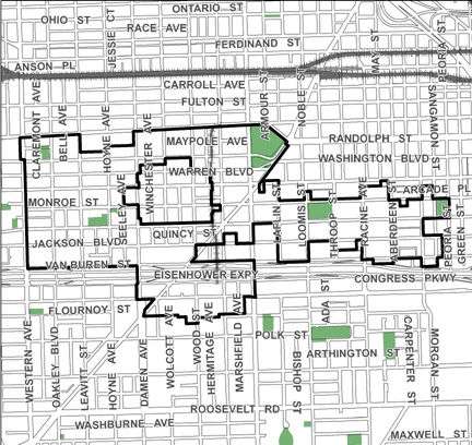
Central West TIF
| Designation: 2000 Expiration: 2036
The 463-acre Near West TIF is intended to facilitate the preparation of vacant and underutilized sites for new retail, commercial and residential development, and off-street parking. Located within the Near West community area, the TIF also is designed to remediate environmental problems at select locations, to provide land for coordinated investment efforts, and to support the development of a variety of housing types that meet the needs of households with a wide range of income levels. Additionally, it provides resources for streetscaping and landscaping to create a distinct area identity and to link its diverse land uses. The TIF also facilitates the improvement and expansion of existing public facilities, such as schools and parks.
Redevelopment Plan (PDF)
|
 |
PROJECTS
Skinner Playlot Park
Skinner Dog Park
Westhaven Park
IMD Blue Line Station
Crane High School
McCrory Senior Apts.
- Redevelopment Agreement
- Community Development Commission Staff Report
- Pre-Development Property Taxes
- Certificate of Completion
Chase Elementary School
Skinner Elementary School
Viceroy Apartments (Harvest Commons)
- Redevelopment Agreement
- Community Development Commission Staff Report
- Pre-Development Property Taxes
- Certificate of Completion
1358 W. Monroe St.
950 W. Monroe St.
- Redevelopment Agreement
- Redevelopment Agreement Amendment #1
- Community Development Commission Staff Report
- Economic Disclosure Statement
- Certificate of Completion
Sangamon Adams Park
Westhaven Park Homes
- Redevelopment Agreement, Phase 1
- Redevelopment Agreement, Phase 2
- Redevelopment Agreement, Phase 2, Amendment #1
- Community Development Commission Staff Report
- Economic Disclosure Statement
Women's Treatment Center
- Redevelopment Agreement
- Community Development Commission Staff Report
- Economic Disclosure Statement
- Certificate of Completion
- Closeout Letter
Rush University Medical Center
