
Project Background
What is a land use plan?
A land use plan is a planning tool that communicates a community’s vision for how a collection of properties should be used. The plan details specific recommendations for each type of use (e.g., industrial, open space, commercial, etc.). Land use plans are created through a community-driven process. Data such as historical and current use of each individual property and market trends are analyzed. Land use plans establish a set of goals and a vision for an area, including a land use map that communicates desired land uses.
Recommendations may include:
- Types of land use
- Zoning changes
- Transportation and infrastructure investments
- Policies, programs and more
What are design guidelines?
Design guidelines are a set of recommendations that shape the physical form of an individual property. Design guidelines apply to new development, redevelopment and expansion. Not all elements are strictly required; requirements vary by code.
Design guidelines may cover topics such as:
- Site Design: Building orientation, layout, open space, parking and services
- Building Design: Bulk, massing, height and architectural expression
- Landscape: Plant species, fences, soil treatments, lighting and amenities
- Sustainability: Stormwater management, renewable energy and climate change resilience
Project Team
The Calumet Area Land Use Plan and Design Guidelines is being led by the Chicago Department of Planning and Development (DPD) with assistance from a consultant team led by Muse Community + Design, an urban planning and community engagement firm that has worked with the City on several previous projects such as the 95th Street Corridor Plan and City Civics Day.
The Muse-led team includes:
- Lamar Johnson Collaborative — land use framework planning and design guidelines
- Rudd Resources — engagement and communications
- SB Friedman — market analysis and economic development
- Site Design Group — landscape architecture and design guidelines
Planning Partners
The core team is also partnering with local community-based organizations in the Calumet area to ensure community interests are adequately represented throughout the course of the project.
- Calumet Area Industrial Commission (CAIC) — As the Local Industrial Retention Initiative (LIRI) delegate agency for the Calumet, Burnside and Pullman industrial corridors, CAIC provides assistance to industrial businesses to foster business retention, workforce development, industrial policy guidance, and public engagement. CAIC is assisting the planning team with outreach to industrial and manufacturing businesses and workers.
- Calumet Connect Partnership — A collection of local and civic organizations established to envision a better Calumet River region. Through their Technical Assistance Team, the Calumet Connect Partnership provides community outreach and strategy support, especially with individuals and organizations interested in environmental justice and local economic development issues.
Community Engagement Methods
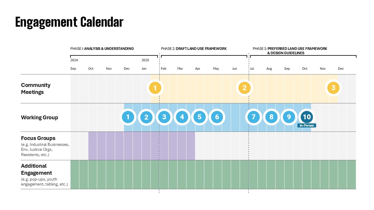
Focus groups: One-time, small group discussions focused on a specific stakeholder type (e.g. residents, manufacturing businesses, environmental justice organizations, etc.); 10 total sessions.
Working group: The working group includes representatives from local industrial businesses, community organizations, City departments and aldermanic representatives. The working group meets approximately once a month to discuss planning topics and assist with developing and vetting plan recommendations.
Community meetings: Large-format community meetings will occur once in each phase to solicit public feedback on project goals and priorities, draft land use framework and design guideline ideas and the final recommendations.
Additional Engagement: Methods such surveys, pop-ups, tabling and interviews will be aimed at engaging additional stakeholders and meeting people where they are.